This Terengganu-speaking island in the center of Malaysia actually belongs to… Indonesia?

- 3.2KShares
- Facebook3.1K
- Twitter11
- LinkedIn14
- Email20
- WhatsApp47
[This article was originally written by our friends over at Soscili last year. To read the original article in BM, click here!]
In the past, we’ve written quite a bit about islands in Malaysia, but we’ve barely scratched the surface. Sabah alone has 394 islands, and according to reports, there are about 878 islands in Malaysia, and some are still not given official names. That number may seem a lot, but it doesn’t include this large-ish group of islands smack in the center between east and west Malaysia:
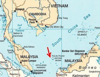
Despite its location, the group of 272 islands, known as the Natuna Archipelago, actually belong to our neighbor Indonesia. The islands have an interesting position where geographically, they may be Malaysian, but in terms of sovereignty, they are Indonesian. Which may explain why…
The Indonesian islanders speak Malay in the Terengganu dialect

While the Natuna Archipelago consists of 272 islands, most of them are uninhabited. The biggest island is known as either Pulau Serindit or Pulau Bunguran locally, but internationally it is known as Pulau Natuna. As of 2010, an estimated 69,000 people live there, with men outnumbering women. A majority of the inhabitants (85.27%) are Malays, while the rest are Javans, Sumaterans and Chinese.
As the header had spelled out already, due to its closeness with Malaysia, most of the islanders speak with a Terengganu dialect. With its 60,000-plus population growing, Natuna is having problems in giving its inhabitants jobs, with most of them still involved in fishing. However, with its natural beauty, Natuna’s tourism sector is expected to grow soon, creating more jobs.

But all that aside, how come Indonesia has a franchise so deep within Malaysia? To answer that question, we’ll have to look back at the island’s history. Back in 1597, nobles from Patani and Johor migrated there and started a kingdom. After Malacca’s fall in the 16th century, the Patani and Johor governments emerged as a new power in the Malay archipelago. The Patani sultanate‘s power at that time was centered on Terengganu, Kelantan, Narathiwat and Yala, while the Johor sultanate held areas to the south, including Pahang, part of Sumatera’s east coast and the Riau islands.
Natuna became involved with Patani when a Natuna princess married a member of the Patani royal family. The resulting son went on to become the Datuk Kaya, the person at the top of Natuna’s rule. Natuna was also said to have good ties with the English, thanks to one of its rulers, Wan Muhammad al-Fathani. For rescuing an English ship that wrecked near Natuna, Lieutenant Colonel Butterworth gifted him a cannon in 1848, which showed that the ruler of Natuna had close relations with the Malay sultanate on the Peninsular.
But what do all these have to do with Natuna being Indonesian? We’re getting there.
Indonesia kind of got a head start in claiming Natuna

As we’ve learned in History, the industrial revolution gave start to colonizing operations by the world’s big powers at that time. The Malay archipelago was no exception, being targeted by the British and the Dutch. Looking at it from the very beginning, Malacca fell first to the Portuguese in 1511, then the Dutch in 1641. Bengkulu, in Sumatra, on the other hand was held by the British since 1685.
Due to a need to fuel the revolution back in both their home countries, the two powers rivaled each other. To stop the rivalry from escalating any further while still safeguarding their interests, the 1824 Anglo-Dutch Treaty was drawn up, at the cost of breaking up the archipelago.
“…the local Malay kingdoms were mostly free until the 1824 British-Dutch Treaty was signed. The treaty was ratified by the colonizing powers without considering its effects on the sociopolitical scenario of the Malay World at that time,” – Dr Hazmi Rusli, law expert, translated from Astro Awani.
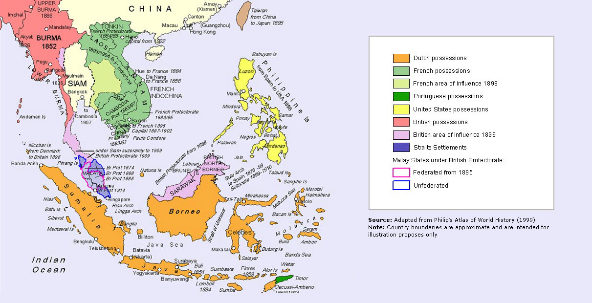
Through the treaty, Malacca was handed over to the British, and the Dutch agreed to not build any settlements on Singapore and the Malay Peninsula. In return, the British recognized the Dutch’s hold over Sumatera and the islands south of Singapore. This colonial divide was later on accepted and became the reason why Malaysia and Indonesia are now separate countries.
Then came the World War 2, when many Asian countries fell to Japan. After Nagasaki and Hiroshima got nuclear bombed in 1945, Japan laid down their arms, and consequently their hold over many countries. For Indonesia, that resulted in their independence on the 17th of August 1945, but not so for Malaya, who faced another threat in the form of communist insurgencies and had to be re-colonized by the British.

In 1956, a year before Malaya gained her independence, Indonesia declared the Natuna Regency as part of Indonesian territory.
“Kabupaten (the regency of) Natuna was then established in the Provinsi Kepulauan Riau based on Law No. 53 1999, which came into force on the 12th October 1999.” – Dr Hazmi Rusli, law expert, translated from mStar.
According to Dr Hazmi, as Natuna was still in the overall territory of Johor when the 1824 treaty was signed, it should have been under British rule, who was the patron of the Johor Sultanate at that time. But it seemed that it will take more than history and a weird ass border to stop Indonesia.
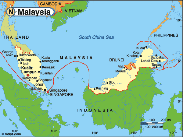
Regardless, Indonesia seemed to have beaten us to the punch by their 1956 declaration, and the Malaysia-Indonesia confrontation between 1962 and 1966 caused Malaysia to focus more on ending our neighborly conflict and less on claiming islands. However, even after the confrontation ended, Malaysia kept her decision to not claim sovereignty of Natuna. In other words, we had recognized Natuna as a district of Indonesia.
Even if we did back off…
Natuna’s location can be a problem for Indonesia

In 2016, Indonesian media was all over the Air Force of the Indonesian National Army’s (TNI-AU) action in driving off Malaysian Royal Air Force’s (TUDM) aircraft, which was said to have used the air space near Natuna on its way to Labuan. However, Malaysia had denied the reports, saying that the aircraft was neither intercepted nor driven off, only having a visual identification done by TNI-AU to confirm the identification of the country the aircraft belonged to.
Whatever the narrative, this incident showed that Indonesia does not mess around when it comes to their sovereignty. Sitting quite far from the rest of Indonesia yet being relatively close to other countries north, east and west of it, Jakarta may have problems maintaining security in the area. Illegal fishing cases in the area were said to cost them USD$25 billion every year, although that figure was said to be grossly overinflated due to a lack of infrastructure to support a fishing industry of that size.
Still, Indonesia also has to deal with China at the Natuna archipelago, as their Exclusive Economic Zone (EEZ) within 200 nautical miles of the islands overlap with China’s nine-dash line in the South China Sea. In case you didn’t know what that is, it’s a series of claims made by China over territories in the South China Sea, and you can read a bit on it here.

And this situation puts Indonesia in a bit of an awkward spot.
“While it does not want to overtly antagonize Beijing, Jakarta feels it must do something to challenge China’s claim. Several Chinese fishing vessels had been arrested, which in 2013, triggered a brief skirmish involving one Indonesian patrol boat. Nevertheless, the number of Chinese vessels arrested in the area thus far pales in comparison to that of the Vietnamese and Thais.” – Excerpt from RSIS.
Indonesia chose to maintain a moderate military patrol on the archipelago, as pulling in foreign investors (like China) can help balance its lack of military strength by having other countries recognize and respect its sovereignty, but when it comes to border problems…
Indonesia’s not the only one threatened by China’s expansion
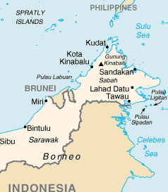
For neighboring countries, misunderstandings and disputes regarding borders can be inevitable at times. Back then, Malaysia and Indonesia once had a pretty serious dispute regarding Pulau Sipadan and Pulau Ligitan, but the International Court of Justice (ICJ) finally ruled that both islands are verified to be Malaysia’s. In the case of the dispute regarding Pulau Batu Puteh with Singapore, Singapore won.
Getting to the present, it would seem that ASEAN countries are facing a China bent on increasing its influence in the South China Sea. This can be seen through a series of demands based on the nine-dash line in the South China Sea, which included the maritime areas of other ASEAN countries. The move created anxiety among ASEAN countries, as their Exclusive Economic Zones may be affected.
“Malaysia do not recognize China’s demand as lined out through the nine-dash line as it is not consistent with international laws including the United Nation Convention regarding the Laws of the Seas (UNCLOS) 1982,” – Datuk Seri Anifah Aman, former Foreign Minister, translated from Sinar Harian.

In addition to that, China is also building artificial islands in the South China Sea. It would seem that China’s actions in the area will continue to be a source of worry among nearby countries. During these trying times, the strength, loyalty and cooperation between ASEAN countries will be put to the test.
[This article heavily referred the works of Dr Hazmi Rusli, Dr Mohd Afandi Salled and Dr Wan Izatul Asma Wan Talaat, published in Astro Awani and mStar.]
- 3.2KShares
- Facebook3.1K
- Twitter11
- LinkedIn14
- Email20
- WhatsApp47


